Congratulations to everyone living along the downtown portion of Toronto’s waterfront, all 65,000 of you who, for decades, have been clumped together on the city’s official map of neighbourhoods as one ill-defined, enormous blob called “Waterfront Communities — The Island.”
Big ups also to Liberty Village, Fort York, West Queen West, and all of Ontario Place, which together will no longer be classified by the city as one sprawling super-hood called “Niagara.”
Toronto is finally redrawing its seemingly-ancient map of neighbourhoods to better reflect how more than a dozen monolithic regions across the city are actually divided in terms of population and use.
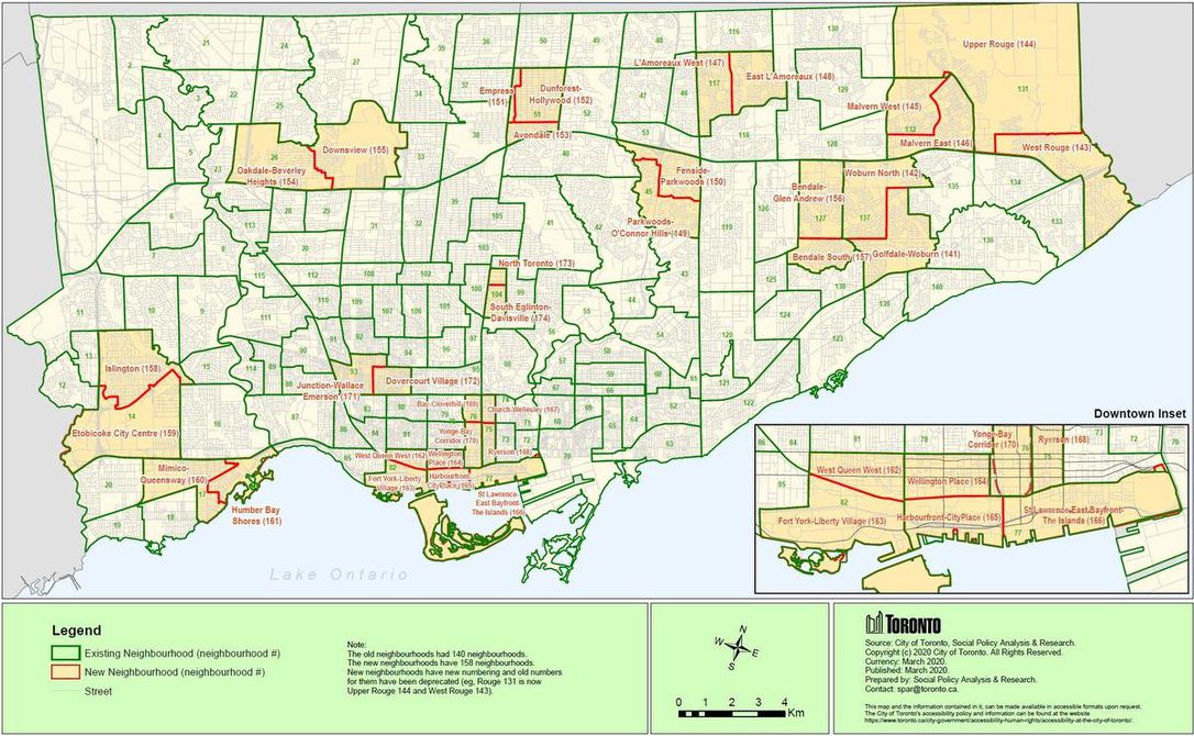
Freshly unveiled by the municipal government, these new boundaries present a Toronto with 158 different neighbourhoods — up from the current total of 140, which has been in place since the late 1990s.
“In recent years population growth has made each neighbourhood’s population unbalanced in relation to the others,” reads the city’s website under a headline that states “Neighbourhoods Are Changing.”
“To balance population growth, the Social Research & Information Management unit (SRIM), together with partners in other City divisions and public agencies, developed neighbourhood splits that resulted in 34 new neighbourhood areas with more balanced populations.”
Are you used to saying that the City of Toronto has 140 neighbourhoods? Well, that number is about to be updated to 158 (h/t @Diane_Dyson).
And, since the old numbers are being retired, we’ll now have 158 neighbourhoods numbered 1-174.https://t.co/NMl0nurIdv pic.twitter.com/9EWcpLrfqz
— Shauna Brail (@shaunabrail) March 15, 2021
It’s not yet clear when the new boundaries will be formally recognized, but the city has released a map showing how large areas such as Rouge, Dovercourt-Wallace Emerson-Junction and Islington-City Centre West are being divvied up.
The latter neighbourhood, for instance, will be split in half horizontally, creating two new hoods called Islington and Etobicoke City Centre.
With more than 43,000 residents as of the last Canadian census, this makes sense.
The area currently known as Willowdale East (population 50,434 as of the last census) will be split into three new neighbourhoods called Empress, Avondale and Dunforest-Hollywood, which I’m certain people will eventually call “Hollywood North (of Bloor.)”
Downtown, the neighbourhood currently known as Niagara will be split into West Queen West and Fort York-Liberty Village.
Waterfront Communities—The Island will become three new hoods called Wellington Place, Harbourfront CityPlace, and St. Lawrence-East Bayview-The Islands.
Here’s the new downtown neighbourhoods that’ll come into effect later this year. Quibbles: Is “Wellington Place” actually a thing? And, uh, are we totally sure we want to name more things after Ryerson? pic.twitter.com/QzQHFQS5cN
— Matt Elliott (@GraphicMatt) March 15, 2021
In total, 16 old neighbourhoods are being replaced with 34 new ones. The rest will stay the same, as will the outer boundaries of all old neighbourhoods.
“Only internal lines are made for new neighbourhoods. This allows old neighbourhoods to be compared to new neighbourhoods,” explains the city. “Neighbourhood splits follow Statistics Canada’s census tract geography for maximum compatibility with existing datasets.”
Confused? This map from the city shows the locations, names, numbers and split lines of both new and old neighbourhoods.
In terms of the city’s old neighbourhood numbering system, all areas being split up will effectively see their numbers retired.
New neighbourhoods have been given numbers starting at 141 and going up to 174. Minus the old neighbourhoods, Toronto has 158 different areas that residents can call home on the new map.
Frivilous as it may seem to do all of this work just to rename a bunch of blocks, Toronto’s neighbourhood profiles are more than a vanity project — they exist to help government and community agencies with local planning by providing socio-economic data on a meaningful geographic scale.


")

 Maziar Moini, Broker of Record - Home Leader Realty Inc.
300 Richmond St. W., #300, Toronto, ON M5V-1X2
Maziar Moini, Broker of Record - Home Leader Realty Inc.
300 Richmond St. W., #300, Toronto, ON M5V-1X2